Private Pilot Final Exam Prep Notes
5/13/22 – passed my Knowledge Exam
- Actual lapse rate- the rate at which temperature changes with height in the atmosphere; it can be used as a measurement to determine the stability of the atmosphere
- What should be the indication on the magnetic compass as you roll into a standard rate turn to the right from a south heading in the Northern Hemisphere? When on a southerly heading in the Northern Hemisphere and you roll into a standard rate turn to the right, the magnetic compass indiation precedes the turn, showing a greater amount of turn than is actually occurring
- During operations outside controlled airspace at altitudes of more than 1,200 feet AGL, but less than 10,000 feet MSL, the minimum distance below clouds requirement for VFR flight at night is 500 ft. Outside controlled airspace (Class G airspace) at altitudes above 1200 ft AGL and less than 10,000 ft MSL, the minimum distance below clouds requirement for VFR Flight at night is 500 ft.
- Outlook briefing: a weather briefing that is provided when the info requested is 6 or more hours in advance of the proposed departure time
- Standard briefing should be obtained before every flight; it provides all the necessary weather and NOTAM info needed
- Abbreviated briefing will be given when the user requests info to supplement mass disseminated data, update a previous briefing, and just needs specific info like only ceiling and visibility changes from the previous briefing
- METARs- issued +55 past the hour and valid hourly; aviation routine weather reports; actual surface weather observations at the time indicated on the report. METARs are NOT forecasts; they read:
- Type of report: Metar or Speci
- ICAO station identifier
- Date and Time of report with Z for Zulu time
- Modifier – if required
- Wind- reported in knots (KT) as a five-digit group. If gusty, reported as G after the speed, followed by the highest gust reported
- Visibility- the prevailing visibility is reported in statute miles, denoted with SM;
- Weather phenomena: ex RA = rain
- Sky condition – ceiling is the lowest broken or overcast layer, or vertical visibility into an obscuration. Cloud bases are reported with three digits in hundreds of feet AGL. OVC007 = overcast cloud layer at 700ft AGL
- Temperature/dew point: they are reported in a two-digit form in whole degrees celsius seperated by a slash
- Altimeter setting
- Remarks (RMK) example – RAB35 means rain begins at 35 mins past the hour
- METAR example: METAR KAUS 301651Z 12008KT 4SM – RA HZ BKN010 OVC023 21/17 A3005 RMK RAB25
- On the 30th of the month at 16:51 Zulu, Winds are from 120 degrees true at 8 knots, visibility is 4 statute miles with Rain and Haze and broken clouds at 1000ft with overcast at 2300 feet. Dew point is 21 degrees c with temperature at 17 deg c. altimeter setting is 30.05, rain beginning at 25 mins past the hour
PIREPS-
- Type of Report:
- Urgent (UUA) – Any PIREP that contains any of the following weather phenomena: tornados, funnel clouds, waterspouts; severe or extreme turbulence: including clear air turbulence (CAT); severe icing; hail; low-level wind shear (LLWS) (pilot reports air speed fluctuations of 10 knots or more within 2000 ft of surface); any other weather phenomena reported which are considered by the controller to be hazardous, or potentially hazardous to the flight operations
- Routine (UA) – Any PIREP that contains weather phenomena listed above including low-level wind shear reports with air speed fluctuations of less than 10 knots
- /OV location: use 3 or 4 letter airport location identifier; position can be over a site, at some location relative to a site or along a route /OV KABC
- /TM Time: four digits in UTC ex: /TM 0915
- /FL Altitude/Flight level: Three digits for hundreds of feet with no space between FL and altitude. If not known use UNKN; ex: /FL095 = 9500; /FL310 = 31,000; /FLUNKN = unknown
- /TP Aircraft Type: four digits maximum; if not known, use UNKN. Ex: /TP L329; TP B737; /TP UNKN
- /SK Sky cover: Describes cloud amount, height of cloud bases, and height of cloud tops; if unknown, use UNKN; ex: /SK SCT040-TOP080
- /WX flight visibility and weather: Flight visibility (FV) reported first and use standard METAR weather symbols. Intensity (- for light, no qualifier for moderate, and + for heavy)
- /TA Temperature: If below zero, prefix with an “M”; ex. /TA 15; /TA M06
- /WV Wind: direction from which the wind is blowing coded in tens of degrees using three digits. Ex: /WV 27045KT
- /TB Turbulence: use standard contractions for intensity and type. Include altitude only if different from FL (flight level). Ex: /TB EXTRM; /TB OCNL LGT-MDT BLO 090;
- /IC Icing: describe using standard intensity and type contractions. Include altitude only if different from FL (flight level). Ex: /IC LGT-MDT RIME; /IC SEV CLR 028-045;
- /RM Remarks: Use free form to clarify the report putting hazardous elements first; ex: /RM LLWS – 15 KT SFC-030 DURGC RY 22 JFK
- The greatest flight condition in a single-engine airplane where torque effect is the greatest is: slow (low airspeed), high power, and high angle of attack
- What causes variations in altimeter settings between weather reporting points? Unequal heating of the earth’s surface
- Current NOTAM and FDC NOTAMs are contained in the Notices to Airmen Publication (NTAP). The NTAP contains D NOTAMs that are expected to remain in effect for an extended period and FDC NOTAMs that are current at the time of publication
- What is the difference in D NOTAMs and FDC NOTAMS
- The minimum safe altitude over a congested area is 1,000 feet above the highest obstacle within a horizontal radius of 2,000 ft of the aircraft.
- VFR Flight in controlled airspace above 1,200 feet AGL and below 10,000 feet MSL requires a minimum visibility and vertical cloud clearance of: 3 miles, and 500 feet below or 1,000 feet above the clouds in controlled airspaces
- If an omnibearing selector (OBS) is set on 253 degrees, with a TO indication and a right course deviation indicator (CDI) deflection. What is the aircraft’s position from the VOR?
- Write the word VOR on a piece of paper. Now draw a line through it, representing the 253 degree radial and its reciprocal. Now imagine you are flying along this line on a heading of 253 degrees. With a TO indication and a right CDI deflection, you are northeast of the VOR but south of the course.
- Locations for VOR test facilities can be found on US Chart Supplement; in each Airport/Facilities Directory, there is a section, listed by state, of VOT ground locations and airborne checkpoints.
- Unless each occupant is provided with supplemental oxygen, no person may operate a civil aircraft of U.S. registry above a maximum cabin pressure altitude of 15,000 ft MSL. No person may operate a civil aircraft of US registry at cabin pressure altitudes above 15,000 MSL unless each occupant is provided with supplemental oxygen
- Contained in a Convective SIGMET is information about tornadoes, embedded thunderstorms, and hail ¾ inch or greater in diameter; Convective SIGMETS are issued for tornadoes, lines of thunderstorms embedded thunderstorms of any intensity level, areas of thunderstorms greater than or equal to VIP level 4 with an area of coverage of 40% or more, and hail ¾ inches or greater
- Batteries in an emergency locator transmitter (ELT) are replaced or recharged, if rechargeable, when the ELT has been in use for more than 1 cumulative hour or when 50% of their useful life (or useful life of charge) has expired.
- May a pilot operate an aircraft that is not in compliance with an Airworthiness Directive (AD)? Yes, if allowed by the AD. An AD is used to notify aircraft owners and other interested persons of unsafe conditions and prescribe the conditions under which an aircraft may continue to be operated. An AD may be one of an emergency nature requiring immediate compliance within a relatively longer period of time. You may operate an airplane that is not in compliance with an AD, if such operation is allowed by the AD.
- Under what condition may a pilot fly through a restricted area (if any)? With the controlling agency’s authorization. An aircraft may not be operated within a restricted area unless permission has been obtained from the controlling agency. Frequently, the ATC within the area acts as the controlling agent’s authorization; for example, an approach control in a military restricted area can permit aircraft to enter it when the restricted area is not active.
- Except in Alaska, during what time period should lighted position lights be displayed on an aircraft? Sunset to Sunrise. Except in Alaska, no person may operate an aircraft during the period from Sunset to sunrise unless the aircraft’s lighted position lights are on.
- Changes in the center of pressure of a wing affect the aircraft’s: aerodynamic balance and controllability. Center of pressure (CP) is the imaginary by determinable point at which all of the upward lift forces on the wing are concentrated. In general, at high angles of attack, the CP moves forward, while at low angles of attack the CP moves aft. The relationship of the CP to center of gravity (CG) affects both aerodynamic balance and controllability.
- Absence of the sky condition and visibility on an ATIS broadcast indicates that the ceiling is at least 5,000 feet and visibility is 5 miles or more. The ceiling/sky condition, visibility, and obstructions to vision may be omitted from the ATIS broadcast if the ceiling is above 5,000 feet with visibility more than 5 statute miles.
- Radar Summary Charts show lines and cells of hazardous thunderstorms that are not shown on other weather charts.
- How are significant weather prognostic charts best used by a pilot? For determining areas to avoid such as freezing levels and turbulence. Weather prognostic charts forecast conditions that exist 12 and 24 hours in the future. They include two types of forecast: low level significant weather, such as IFR and marginal VFR areas, and moderate or greater turbulence areas and freezing levels
- Advection fog and upslope fog depend upon wind in order to exist. Advection fog forms as warmer, moist air moves over a cold ground. The air is cooled to saturation by the cold from the ground below cooling the air above. Unlike radiation fog, advection fog may form under cloudy skies and with moderate to strong winds.
- In which situation is advection fog most likely to form? An air mass moving inland from the coast in winter. Advection fog forms when warm moist air moves over colder ground or water. It is most common in coastal areas.
- What are characteristics of a moist, unstable air mass? Cumuliform clouds and showery precipitation
- Cumulonimbus – the thunderstorm clouds with the greatest turbulence
- US Airspace Classes
- A: 18,000 MSL; ATC clearance to enter; Must have Instrument rating; Yes need 2-way communication; Yes need Altitude Decoding Transponder, Min visibility and cloud clearances don’t apply
- B: ATC clearance to enter; Must have Private Certificate or student with endorsement; Yes, must have 2-way communication; Yes must have Altitude Decoding Transponder within 30 NM of class B primary airport; VFR min visibility is 3 miles and clear of clouds
- C: VFR requires radio contact to enter and IFR requires clearance to enter; student certificate; Yes, the two way communication, Yes requires Altitude Decoding Transponder within C space and above lateral limits of C space; 3 miles of visibility; 500 below clouds, 1000 above and 2000 horizontal
- D: VFR requires radio contact to enter airspace; IFR clearance to enter; requires student certificate; yes, requires 2-way communication; Altitude decoding transponder is not required unless required by other airspace; 3 miles of visibility; 500 below; 1000 above; 2000 hortizontal cloud clearances; The lateral dimensions of Class D airspace are based on the instrument procedures for which the controlled airspace is established.
- E: VFR no requirement to enter; IFR clearance to enter; student certificate; 2 way communication only required with IFR; Altitude decoding transponder is not required unless required by other airspace; 3 miles VFR minimum visibility below 10,000 MSL; 5 miles VFR min visibility 10,000 MSL and above; VFR Cloud Clearance below 10,000 MSL: 500 below, 1000 above, 2000 horizontal; VFR Cloud Clearances 10,000 MSL and above: 500 below, 1000 above, 1 mile horizontal clearance; Non-towered airports, above 700 AGL, 1,200 AGL (class G is below E)
- G: No requirements to enter; Student certificate required; No 2 way communication required; No altitude decoding transponder required; VFR Min Visibility below 10,000 MSL requires Daytime 1 mile and Night: 3 miles; VFR min visibility 10,000 MSL and above: 5 miles; VFR Cloud Clearance below 10,000 MSL 500 below, 1000 above; 2000 horizontal; VFR Cloud Clearance 10,000 MSL and Above 500 below, 1000 above, 1 mile horizontal
- The amount of excess load that can be imposed on the wing of an airplane depends upon the speed of the airplane. The amount of excess load that can be imposed on the wing depends upon how fast the airplane is flying. At low speeds, the maximum available lifting force of the wing is only slightly greater than the amount necessary to support the weight of the airplane. Thus, any excess load would simply cause the airplane to stall. At high speeds, the lifting capacity of the wing is so great (as a result of the greater flow of air over the wings) that a sudden movement of the elevator controls (strong gust of wind) may increase the load factor beyond safe limits. This is why maximum speeds are established by airplane manufacturers.
- Outside controlled airspace, the minimum flight visibility requirement for VFR flight above 1,200 feet AGL and below 10,000 feet MSL during daylight hours is 1 mile. Outside controlled airspace (i.e., Class G airspace) at altitudes above 1,200 ft; below 10,000 ft MSL, the minimum flight visibility requirement for VFR flight during day is 1 statute mile
- When does the P-factor cause the airplane to yaw to the left? When at high angles of attack. P-factor or asymmetric propeller loading occurs when an airplane is flown at a high angle of attack because the downward-moving blade on the right side of the propeller (as seen from the rear) has a higher angle of attack, which creates higher thrust than the upward-moving blade on the left. Thus, the airplane yaws around the vertical axis to the left.
- When departing behind a heavy aircraft, the pilot should avoid wake turbulence by maneuvering the aircraft above and upwind from the heavy aircraft. The proper procedure for departing behind a larger aircraft is to rotate prior to the large aircraft’s rotation point, then fly above and upwind of the large aircraft. Since vortices sink and drift downwind, this should keep you clear.
- The elevator controls movement above which axis? Lateral. The elevator is the primary control device for changing the pitch attitude of an airplane about the lateral axis.
- In the Northern Hemisphere a magnetic compass will normally indicate a turn toward the north if an aircraft is accelerated while on an east or west heading.
- During the life cycle of a thunderstorm, which stage is characterized predominately by downdrifts? Dissipating. Thunderstorms have three life cycles: cumulus, mature, and dissipating. It is in the dissipating stage that the storm is characterized by downdrafts as the storm rains itself out.
- Except when necessary for takeoff or landing what is the minimum safe altitude for a pilot to operate an aircraft anywhere? An altitude allowing, if a power unit fails, an emergency landing without undue hazard to persons or property on the surface. Except when necessary for takeoff or landing no person may operate an aircraft anywhere below an altitude allowing, if a power unit fails, an emergency landing without undue hazard to persons or property on the surface.
- Which incident requires an immediate notification to the nearest NTSB field office? Flight control system malfunction or failure.
- The NTSB must be notified immediately and by the most expeditious means possible when an aircraft accident or any of various listed incidents occurs or when an aircraft is overdue and believed to have been in an accident. The following are considered incidents:
- Flight controls system malfunction or failure
- Inability of any required flight crewmember to perform normal flight duties as a result of injury or illness
- Failure of structural components of a turbine engine, excluding compressor an turbine blades and vanes
- In-flight fire; or
- Aircraft collision in flight
- The NTSB must be notified immediately and by the most expeditious means possible when an aircraft accident or any of various listed incidents occurs or when an aircraft is overdue and believed to have been in an accident. The following are considered incidents:
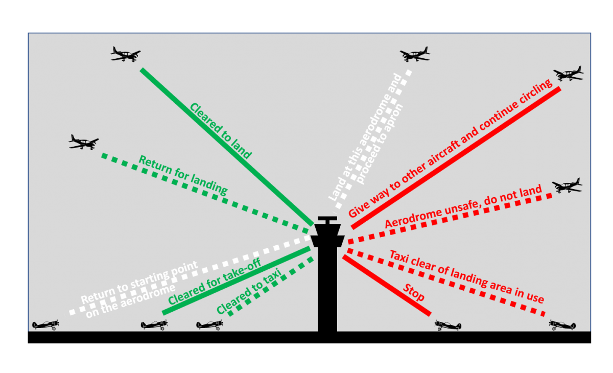
- While on final approach for landing, an alternating green and red light followed by a flashing red light is received from the control tower. Under these circumstances, the pilot should exercise extreme caution and abandon the approach, realizing the airport is unsafe for landing. An alternating red and green light signaled from a control tower means “exercise extreme caution” whether to an airplane on the ground or in the air. The flashing red light received while in the air indicates the airport is not safe, and the pilot should not land.
- Applying carburetor heat will enrich the fuel/air mixture. Applying carburetor heat will enrich the fuel/air mixture. Warm air is less dense than cold air, hence the application of heat increases the fuel-to-air ratio
- How are Significant weather prognostic charts best used by a pilot? For determining areas to avoid (freezing levels and turbulence) – Weather prognostic charts forecast conditions that exist 12 and 24 hrs in the future. They include two types of forecasts: low level significant weather, such as IFT and marginal VFR areas, and moderate or greater turbulence areas and freezing levels.
- What is one of the neglected items when a pilot relies on short and long term memory for repetitive tasks? Checklist; Neglect of checklist, flight planning, preflight inspections, etc., indicates a pilot’s unjustified reliance on his or her short- and long-term memory for repetitive
- During a night flight, you observe a steady red light and a flashing red light ahead and at the same altitude. What is the general direction of movement of the other aircraft? The other aircraft is crossing to the left. Airplane position lights consist of a steady red light on the left wing (looking forward), a green light on the right wing, and a white light on the tail. Accordingly, if you observe a steady red light, you are looking at the tip of a left wing, which means the other plane is traveling from your right to left (crossing to the left). The red flashing light is the beacon.
- If a flight is made from an area of low pressure into an area of high pressure without the altimeter setting being adjusted, the altimeter will indicate lower than the actual altitude above sea level. When an altimeter settign is at a lower value than the correct setting, the altimeter is indicating less than it should and thus would be showing lower than the actual altitude above sea level.
- With respect to the certification of aircraft, which is a category of aircraft? Normal, utility, acrobatic; Category of aircraft, as used with respect to the certification of aircraft, means a grouping of aircraft based upon intended use or operating limitations. Examples include transport, normal, utility, acrobatic, limited, restricted, and provisional.
- How can you determine if another aircraft is on a collision course with your aircraft? There will be no apparent relative motion between your aircraft and the other aircraft. Any aircraft that appears to have no relative motion and stays in one scan quadrant is likely to be on a collision course. Also, if a target shows no lateral or vertical motion but increases in size, take evasive action
- Ground-Based Navigation – 3 radio Navigation systems available for use for VFR:
- VHF Omnidirectional Range (VOR)
- Nondirectional Radio Beacon (NDB)
- GPS
- Very High Frequency (VHF) Omnidirectional Range (VOR) system is present in 3 slightly different navigation aids (NAVAIDs):
- VOR
- VOR/DME (Distance measuring equipment) – when DME is installed with VOR
- VORTAC – when military tactical air navigation (TACAN) equipment is installed with a VOR, the NAVAID is known as a VORTAC. DME is always an integral part of a VORTAC.
- By itself it is known as VOR provides magnetic bearing information to and from the station. Regardless of the type of NAVAID utilized, the VOR indicator behaves the same. All referred to hereafter as VORs. The course or radials projected from the station are referenced to magnetic north (MN). a radial is defined as a line of magnetic bearing extending outward from the VOR station. Radials are identified by numbers beginning with 001, which is 1 degree east of Magnetic North and progressing in sequence through all of the degrees of a circle until reaching 360. To aid in orientation, a compass rose reference to magnetic north is superimposed on aeronautical charts at the station location
- The aircraft equipment includes a receiver with a tuning device and a VOR or Imninavigation instrument. The nav instrument could be a: course deviation indicator (CDI), horizontal situation indicator (HSI) or a radio magnetic indicator (RMI). Each instrument indicates the course to the tuned VOR.
- CDI: a CDI is found in most training aircraft. It consists of an omnibearing selector (OBS) sometimes referred to as the course selector, a CDI needle (left-right needle) and a TO/FROM indicator.
- HSI: a direction indicator that uses the output from a flux valve to drive the compass card. Combines the magnetic compass with navigation signals and a glideslope. Gives the pilot an indication of the location of the plane in relation to the chosen course or radial.
- RMI: navigational aid providing plane magnetic or directional gyro heading and very high frequency omnidirectional range (VOR), GPs, and automatic direction finder (ADF) bearing information.
Radio Communications: VHF radio operates on freq btw 118.0 megahertz and 136.975 megahertz and is classified as 720 or 760 depending on the number of channels it can accommodate.
Alfa, Bravo, Charlie, Delta, Echo, Foxtrot, Golf, Ho, Indigo, Juliett, Kilo, Limo, Mike, November, Oscar, Papa, Quebec, Romeo, Sierra, Tango, Uniform, Victor, Whiskey, Xray, Yankee, Zulu,
The numbers 8 and 26 on the approach ends of the runway indicate that the runway is orientated approximately: 080 degrees and 260 degrees magnetic (not true); Runway numbers are determined from the approach direction. The runway number is the whole number nearest one-tenth the magnetic direction of the centerline. Thus, the numbers 8 and 26 on a runway indicate that the runway is oriented approximately 80 and 260 magnetic.
When flying in the airspace underlying Class B airspace, the maximum speed authorized is 200 knots ; No person may operate an airplane in the airspace underlying Class B airspace at an indicated airspeed of more than 200 kt. (230 MPH).
What is the maximum wind velocity for a 30° crosswind if the maximum crosswind component for the airplane is 12 knots. (Refer to Figure 37) 
| Which factor would tend to increase the density altitude at a given airport? An increase in ambient temperature. |
No person may operate an airplane within Class D airspace at night under special VFR unless the airplane is equipped for instrument flight. To operate under special VFR within Class D airspace at night, the pilot must be instrument rated and the airplane equipment for instrument flight.
When the runway holding position line is viewed from the runway side, the pilot is presented with two dashed bars. The PIC must ensure the entire aircraft has cleared the runway holding position line prior to coming to a stop.
The minimum flight visibility required for VFR flights above 10,000 feet MSL and more than 1,200 feet AGL in controlled airspace is 5 miles. Controlled airspace is the generic term for Class A, B, C, D, or E airspace. Of these, only in Class E airspace is the minimum flight visibility 5 SM for VFR flights at or above 10,000 ft MSL.
Dashed magenta line around an airport = class E airspace from the surface
Under which condition will pressure altitude be equal to true altitude? When standard atmospheric conditions exist. Pressure altitude equals true altitude when standard atmospheric conditions (29.92″ Hg and 15°C at sea level) exist.
If instructed by ground control to taxi to Runway 9, the pilot may proceed to the next intersecting runway where further clearance is required. A taxi clearance from ATC authorizes the pilot to utilize taxiways along the taxi route, but a specific crossing clearance must be issued for all runways along the route.
When an air traffic controller issues radar traffic information in relation to the 12-hour clock, the reference the controller uses is the aircraft’s ground track. When issuing radar traffic information, the controller will provide the direction of the traffic from your airplane in relation to the 12-hr. clock based on your ground track or magnetic course.
What is the relationship of lift, drag, thrust, and weight when the airplane is in straight-and-level flight?
Lift equals weight and thrust equals drag. When the airplane is in straight-and-level flight (assuming no change of airspeed), it is not accelerating, and therefore lift equals weight and thrust equals drag.
When approaching Lincoln Municipal from the west at noon for the purpose of landing, initial communications should be with (Refer to Figure 53) Lincoln Approach Control on 124.0 MHz. Fig. 53 contains the A/FD excerpt for Lincoln Municipal. Locate the section titled Airspace and note that Lincoln Municipal is located in Class C airspace. The Class C airspace is in effect from 0530-000 local time (1130-0600Z). You should contact approach control (app con) during that time before entering. Move up two lines to App/Dep Con and note that aircraft arriving from the west of Lincoln (i.e., 170° – 349°) at noon should initially contact Lincoln Approach Control on 124.0.
Which cruising altitude is appropriate for a VFR flight on a magnetic course of 135°? Odd thousand plus 500 feet. When operating a VFR flight above 3,000 ft. AGL on a magnetic course of 0° through 179°, fly any odd thousand-ft. MSL altitude plus 500 feet. Thus, on a magnetic course of 135°, an appropriate VFR cruising altitude is an odd thousand plus 500 feet.
Which items are included in the empty weight of an aircraft? Unusable fuel and undrainable oil. The empty weight of an airplane includes airframe, engines, and all items of operating equipment that have fixed locations and are permanently installed. It includes optional and special equipment, fixed ballast, hydraulic fluid, unusable fuel, and undrainable oil.
If 50 pounds of weight is located at point X and 100 pounds at point Z, how much weight must be located at point Y to balance the plank? (Refer to Figure 62) 300

Ground effect is most likely to result in which problem? 3. Inability to get airborne even though airspeed is sufficient for normal takeoff needs.
How should the 500-pound weight be shifted to balance the plank on the fulcrum? (Refer to Figure 61)
1 inch to the left.
To find the desired location of the 500-lb. weight, compute and sum the moments left and right of the fulcrum. Set them equal to one another and solve for the desired variable:
left = right
500 lb.(X) = 250 lb.(20in.) ÷ 200 lb.(15in.)
500X = 8,000
X = 16 in.
The term “category,” as used with respect to the certification of aircraft, means a grouping of aircraft based on their intended use or operating limitations, for example, normal, utility, acrobatic, or primary.
If the outside air temperature (OAT) at a given altitude is warmer than standard, the density altitude is higher than pressure altitude.
At approximately what altitude above the surface would be pilot expect the base of cumuliform clouds if the surface air temperature is 82F and the dew point is 38F:
Answer:
10,000 feet AGL
Explanation: the difference of temperature is 82°F – 38°F = 44°F
Now we have that temperature/dew point spread
So replacing the data we obtain 44°F/4.4°F = approximately 10,000 ft. AGL.
Ground effect is most likely to result in which problem? Becoming airborne before reaching recommended takeoff speed. Due to the reduction of induced drag in ground effect, the airplane may seem capable of becoming airborne well below the recommended takeoff speed. However, as the airplane rises out of ground effect (a height greater than the wingspan) with a deficiency of speed, the increase in induced drag may result in very marginal initial climb performance. In extreme cases, the airplane may become airborne initially, with a deficiency of airspeed, only to settle back on the runway when attempting to fly out of the ground effect area.
Density altitude is higher than pressure altitude if the outside air temp (OAT) at a given altitude is warmer than standard.
The Weather Depiction chart is of value to the pilot for determining general weather conditions on which to base flight planning.
| FAA Medical Certificate Durations | |||
| Privileges | Under the Age of 40 | Age 40 and Over | |
| First-Class | Airline Transport Pilot | 12 Months | 6 Months |
| Second-Class | Commercial Pilot | 12 Months | 12 Months |
| Third-Class | Private Pilot | 60 Months | 24 Months |
| BasicMed | Private Pilot | 60 Months | 24 Months |
A nautical mile is slightly longer than a mile on land, equaling 1.1508 land-measured (or statute) miles. The nautical mile is based on the Earth’s longitude and latitude coordinates, with one nautical mile equaling one minute of latitude.The familiar land mile is 5,280 feet, is called a statute mile, and it’s based on paces. So a nautical mile is derived from latitude. One minute of latitude is equal to one nautical mile.
You may bring the following items with you to your test:
- Protractor
- Plotter
- E6B flight computer (manual or electronic)
- Small electronic calculator
Unless otherwise authorized, what is the maximum indicated airspeed at which a person may operate an aircraft below 10,000 feet MSL? 250 knots.
Where in the Airport/Facility Directory can you find information where a pilot would need prior authorization from other than ATC to land at certain airports? (Refer to Legend 13) Under Military Remarks. Any civilian pilot who wants to land at a military airport must have a Prior Permission Request (PPR) authorized (usually by the Air Operations Commander) before being authorized to land.
Before a person holding a private pilot certificate may act as pilot in command of a high-performance airplane, that person must have received ground and flight instruction from an authorized flight instructor who then endorses that person’s logbook. A private pilot may not act as pilot in command of a high-performance airplane (an airplane with an engine of more than 200 horsepower) unless (s)he has received and logged ground and flight training from an authorized instructor who has certified in his or her logbook that (s)he is proficient to operate a high-performance airplane.
Which instrument(s) will become inoperative if the static vents become clogged? Airspeed, altimeter, and vertical speed. The pitot-static system is a source of air pressure for the operation of the airspeed indicator, altimeter, and vertical speed indicator. Thus, if the static vents become clogged, all three instruments will become inoperative.
In addition to other preflight actions for a VFR flight away from the vicinity of the departure airport, regulations specifically require the pilot in command to determine runway lengths at airports of intended use and the aircraft’s takeoff and landing distance data. Preflight actions for a VFR flight away from the vicinity of the departure airport specifically require the pilot in command to determine runway lengths at airports of intended use and the aircraft’s takeoff and landing distance data.
Determine the total distance required for takeoff to clear a 50-foot obstacle. (Refer to Figure 41)
OAT………………………Std
Pressure altitude ……… Sea level
Takeoff weight………… 2,700 lb
Headwind component… Calm

Begin in the left section of Fig. 41 by finding the intersection of the sea level pressure altitude and standard temperature (59°F) and proceed horizontally to the right to the first reference line. Then proceed parallel to the closest guideline, to 2,700 pounds. From there, proceed horizontally to the right to the third reference line. You skip the second reference line because the wind is calm. Then proceed upward parallel to the closest guideline to the far right side. To clear the 50-ft. obstacle, you need a takeoff distance of about 1,400 feet.
Determine the approximate manifold pressure setting with 2,450 RPM to achieve 65 percent maximum continuous power at 6,500 feet with a temperature of 36°F higher than standard. (Refer to Figure 36)
21.0″ Hg.The part of the chart on the right is for temperatures 36°F greater than standard. AT 6,500 ft. with a temperature of 36°F higher than standard, the required manifold pressure change is 1/4 of the difference between the 21.0″Hg at 6,000 ft. and the 20.8″Hg at 8,000 ft., or slightly less than 21.0. Thus, 21.0 is the best answer given. The manifold pressure is closer to 21.0 than 20.8.
What is the definition of a high-performance airplane? An airplane with an engine of more than 200 horsepower. A high-performance airplane is defined as an airplane with an engine of more than 200 horsepower.
What is the difference in NOTAM (D) and FDC NOTAMs? Domestic NOTAMS vs Flight Data Center NOTAM; NOTAM D. Contains information for all navigational facilities that are part of the National Airspace System (NAS), all public use aerodromes, seaplane bases, and heliports listed in the Chart Supplement U.S. This type of NOTAM will be omitted during a standard briefing unless requested. FDC, or Flight Data Center NOTAMs outline changes to instrument approach procedures and airways within the U.S. The next time you’re flying IFR, you should be checking them before you go.
What information is contained in the Notices to Airmen Publication (NTAP)? NOTAM (D) and FDC NOTAMs (not Military NOTAMs)
A pilot can expect a wind-shear zone in a temperature inversion whenever the wind speed at 2,000 to 4,000 feet above the surface is at least 25 knots.
What causes an airplane (except a T-tail) to pitch nosedown when power is reduced and controls are not adjusted? The downwash on the elevators from the propeller slipstream is reduced and elevator effectiveness is reduced. The relative wind on the tail is the result of the airplane’s movement through the air and the propeller slipstream. When that slipstream is reduced, the horizontal stabilizer (except a T-tail) will produce less negative lift and the nose will pitch down.
For private pilot operations, a Second-Class Medical Certificate issued to a 42-year-old pilot on July 15, this year, will expire at midnight on July 31, 2 years later. For private pilot operations, a second-class medical certificate will expire at the end of the last day of the month, 2 years after it was issued, for pilots 40 years old or older on the date of the medical examination. For private pilot operations, a second-class medical certificate issued to a 42-year-old pilot on July 15 will be valid until midnight on July 31, 2 years later.
Which approach and landing objective is assured when the pilot remains on the proper glidepath of the VASI? Safe obstruction clearance in the approach area. The visual approach slope indicator (VASI) provides safe obstruction clearance within ± 10° of the extended runway centerline out to 4 NM. Pilots are advised to remain on the VASI-directed glide path throughout the entire approach to ensure obstruction clearance.
The Class C airspace at Metropolitan Oakland International (OAK) which extends from the surface upward has a ceiling of (Refer to Figure 75, area 6)
both 2,100 feet and 3,000 feet MSL.The Class C airspace at OAK (area 6) is shown in solid magenta lines. The surface area over the airport indicates the Class C airspace extends from the surface (SFC) upward to T, which means the ceiling ends at the base of the San Francisco Class B airspace. The base of the Class B airspace changes over OAK. To the left of OAK the base is 2,100 ft. MSL and to the right of OAK the base is 3,000 ft. MSL.
When are two-way radio communications required on a flight from Bishop Airport (area 4) to McCampbell Airport (area 1) at an altitude of 2,000 feet MSL? (Refer to Figure 70) Entering the Corpus Christi Class C airspace. On Fig. 70, area 4 is near the center and area 1 is in the upper right-hand corner of the chart. A flight from Bishop Airport to McCampbell Airport at 2,000 ft. MSL will pass through the Corpus Christi Class C airspace. Two-way radio communications and transponder with encoding altimeter are required when operating within Class C airspace.
Wingtip vortices created by large aircraft tend to sink below the aircraft generating turbulence. Wingtip vortices created by large airplanes tend to sink below the airplane generating the turbulence. (They do not rise into the traffic pattern nor do they rise into the takeoff or landing path of a crossing runway.
VFR flight in controlled airspace above 1,200 feet AGL and below 10,000 feet MSL requires a minimum visibility and vertical cloud clearance of 3 miles, and 500 feet below or 1,000 feet above the clouds in controlled airspace.
VOR/DME navigation facility- the symbol is a hexagon with a dot in the center within a square.
What is ground effect? The result of the interference of the surface of the Earth with the airflow patterns about an airplane.
Land and Hold Short Operations (LAHSO)Pilots should only receive a LAHSO clearance when there is a minimum ceiling of 1,000 feet and 3 statute miles visibility. The intent of having “basic” VFR weather conditions is to allow pilots to maintain visual contact with other aircraft and ground vehicle operations.
“A Special VFR Clearance is an ATC authorization for a VFR aircraft to operate in weather that is less than the basic VFR minima. Basic VFR minima are 1,000-foot ceiling and 3 miles visibility. If the reported weather is less, a pilot can request a Special VFR Clearance. Special VFR is an, on request by pilot only, “required weather minimums” change that may be approved by ATC.
If a pilot suspects that the engine (with a fixed-pitch propeller) is detonating during climb-out after takeoff, the initial corrective action to take would be to lower the nose slightly to increase airspeed. the key here is to attempt to cool the engine to minimize or eliminate the detonation. Leaning the mixture and applying carburetor heat can actually increase engine temperatures.
One of the easiest recognizable changes when flying across a front is a change in temperature.
To best determine general forecast weather conditions over several states, the pilot should refer to Aviation Area Forecasts.
An Aviation Area Forecast is a prediction of general weather conditions over an area consisting of several states or portions of states. It is used to obtain expected enroute weather conditions and also to provide an insight to weather conditions that might be expected at airports where weather reports or forecasts are not issued.
The proper adjustment to make on the attitude indicator during level flight is to align the (Refer to Figure 7) miniature airplane to the horizon bar. The horizon bar (marked as B) on Fig. 7 represents the true horizon. This bar is fixed to the gyro and remains on a horizontal plane as the airplane is pitched or banked about its lateral or longitudinal axis, indicating the attitude of the airplane relative to the true horizon. An adjustment knob is provided, with which the pilot may move the miniature airplane with the horizontal bar to suit the pilot’s line of vision.
The VOR receiver has the indications shown. What is the aircraft’s position relative to the station? (Refer to Figure 29, refer to illustration 3.)
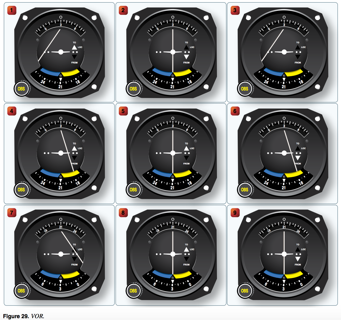
Southeast. With no TO of FROM indications showing on VOR 3, Fig. 29, you must be flying in the zone of ambiguity from the VOR, which is perpendicular to the OBS setting, i.e., on the 120° or 300° radials, Since you have a left deflection, you would be on the 120° radial, or southeast of the VOR. The OBS is a selector knob on a navigational radio. It stands for the “Omni-Bearing Selector,” and it enables a pilot to select which direction they wish to fly towards or away from a VOR navigational beacon or GPS waypoint.
During the time period from 0600Z to 0800Z, what visibility is forecast for KOKC? (Refer to Figure 15) Greater than 6 statute miles.
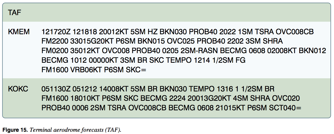
At KOKC, between 0600Z and 0800Z, conditions are forecast to become wind 210° at kt., visibility greater than 6 SM (P6SM), scattered clouds at 4,000 ft. with conditions continuing until the end of the forecast (1200Z).
What aircraft inspections are required for rental aircraft that are also used for flight instruction? Annual condition and 100-hour inspections. All aircraft that are used for hire (e.g., rental) and flight instruction must be inspected on a 100-hr. basis. Also, an annual condition inspection must be completed.

True Altitude is height above mean sea level (MSL). • Absolute Altitude is height above ground level (AGL). • Pressure Altitude is the indicated altitude when an altimeter is set to 29.92
To set high intensity runway lights to medium intensity, a pilot should click the microphone seven times (to turn them on high intensity), then click it five times.
You should anticipate possible mountain wave turbulence when the air is stable and winds of 40 kt. or greater blow across a mountain or ridge.
Which type of radar service is provided to VFR aircraft at Lincoln Municipal? Sequencing to the primary Class C airport, traffic advisories, conflict resolution, and safety alerts.
The possibility of carburetor icing exists even when the ambient air temperature is as high as 70°F and the relative humidity is high.
Testing Emergency Locator Transmitters:
Analog 121.5/243 MHz ELTs should only be tested during the first 5 minutes after any hour. If operational tests must be made outside of this period, they should be coordinated with the nearest FAA Control Tower. Tests should be no longer than three audible sweeps.
Low-level turbulence can occur and icing can become hazardous in which type of fog? Steam fog — forms in winter when cold, dry air passes from land areas over comparatively warm ocean waters and is composed entirely of water droplets that often freeze quickly. Low-level turbulence can occur and icing can become hazardous in steam fog.
An on glide slope indication from a tri-color VASI is: green light Another type of VASI is the Tri-Color VASI, a single light unit projecting three colors. The below glide path indicator is a red light. The above glide path indicator is an amber light. The on glide path indicator is a green light.
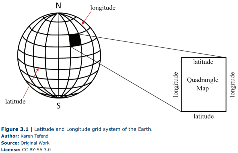
VFR Charts On VFR sectional charts the Maximum Elevation Figure (MEF) gives pilots an obstruction-free altitude. The MEF is determined by rounding the highest elevation (or obstruction height) within the quadrangles of latitude and longitude to the next 100-foot level. These altitudes are then adjusted upward between 100 to 300 feet. On the VFR sectional in figure 1 the MEF is 9,700 feet mean sea level (msl). The highest peak within this quadrangle is (highlighted) 9,396 feet msl. In some cases the MEF can provide as little as 101 feet of obstacle clearance.
When planning a flight, look at the MEF and OROCA. Be sure the planned cruise altitude is above the MEF or OROCA. If you have to descend during a flight due to weather use these altitudes as your de facto minimum cruise altitude. When planning your flight remember that the MEF and OROCA are listed in msl and ceilings are in agl. Ensure that your planned altitude will not only keep you clear of obstacles, but also keep you clear of the clouds. An off-route obstruction clearance altitude (OROCA) is an off-route altitude that provides obstruction clearance with a 1,000-foot buffer in non- mountainous terrain areas and a 2,000-foot buffer in designated mountainous areas within the United States
For private pilot operations, a Second-Class Medical Certificate issued to a 42-year-old pilot on July 15, this year, will expire at midnight on July 31, 2 years later. For private pilot operations, a second-class medical certificate will expire at the end of the last day of the month, 2 years after it was issued, for pilots 40 years old or older on the date of the medical examination. For private pilot operations, a second-class medical certificate issued to a 42-year-old pilot on July 15 will be valid until midnight on July 31, 2 years later.
The tetrahedron points to the wind
Possible mountain wave turbulence could be anticipated when winds of 40 knots of greater blow across a mountain ridge, and the air is stable.
How should the flight controls be held while taxiing a tricycle-gear equipped airplane into a left quartering headwind? Left aileron up, elevator neutral. Given a left quartering headwind, the left aileron should be kept up to spoil the excess lift on the left wing that the crosswind is creating. This elevator should be neutral to keep from putting too much or too little weight on the nosewheel.
Vno is defined as the maximum structural cruising speed. VNO. Normal operating speed, Also called the maximum structural cruising speed. This is the top of the green arc marked on the ASI (air-speed indicator). Beyond this speed is the yellow or cautionary area, which must be avoided while flying in turbulence.
Deviation in a magnetic compass is caused by the magnetic fields within the aircraft distorting the lines of magnetic force. Magnetic fields produced by metals and electrical accessories in the airplane disturb the compass needle and produce errors. These errors are referred to as compass deviation.
Which would provide the greatest gain in altitude in the shortest distance during climb after takeoff? Vx Vx means the best angle of climb airspeed (i.e., the airspeed which will provide the greatest gain in altitude in the shortest distance).
What minimum radio equipment is required for VFR operation within Class B airspace? Two-way radio communications equipment, a 4096-code transponder, and an encoding altimeter. To operate within Class B airspace, the aircraft must have
1. Two-way radio communications equipment.
2. A 4096-code transponder, and
3. An encoding altimeter.
The location of the center of gravity with respect to the center of lift determines, to a great extent, the longitudinal stability of the airplane. Positive stability is attained by having the center of lift behind the center of gravity.
You can also calculate the cloud base using the following formula:
1) Calculate the ‘spread,’ where you’re taking the current temperature and subtracting the dew point.
2) Divide the spread by 4.4 (if temperatures are in °F) or 2.5 (if temperatures are in °C), then multiply by 1000.
This will give you cloud base in feet above ground level.